You won't believe this 'horror picture' is a picture on Earth until you hear NASA explain it
You won't believe this 'horror picture' is a picture on Earth until you hear NASA explain it
Of the 9 million Earth images, these are the best of all time!
Project Landsat, a joint program between NASA and the United States Geological Survey (USGS), is the Earth research project with the most continuous operation in space (nearly 50 years). A total of eight Landsat satellites have been launched into space since 1972, with the ninth to be launched in September 2021.
Over the past 49 years, satellites have captured more than 9 million images of the planet's surface - used in more than 18,000 scientific papers, NASA's Earth Observatory reports.
To celebrate the upcoming 50th anniversary of Project Landsat, Earth Observatory is holding a public contest to select the best Landsat photographs of all time.
And here are Lansat's 10 most beautiful photos of Earth of all time out of 9 million images captured by satellite:
1. Earth and Water blend
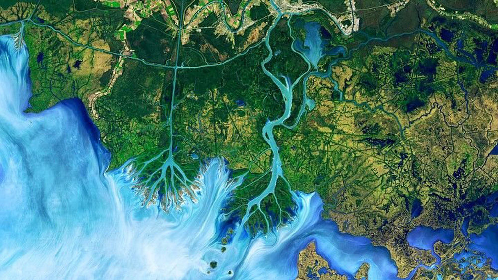
Atchafalaya Plain. (Joshua Stevens / NASA Earth Observatory)
Striking image of the Atchafalaya Plain in Louisiana, USA captured by the Landsat 8 satellite on December 1, 2016.
It's a false color image, meaning the colors have been altered, "emphasizing the difference between land and water, while allowing viewers to observe sediment in the water," explains the Earth Observatory. .
This photo is one of 10,000 images Landsat made between 1982 and 2016 in this area. And it was used in a study published in the journal Geophysical Research Letters, which looked at the role of wind in pond expansion in the Mississippi Delta.
2. Where the dunes end
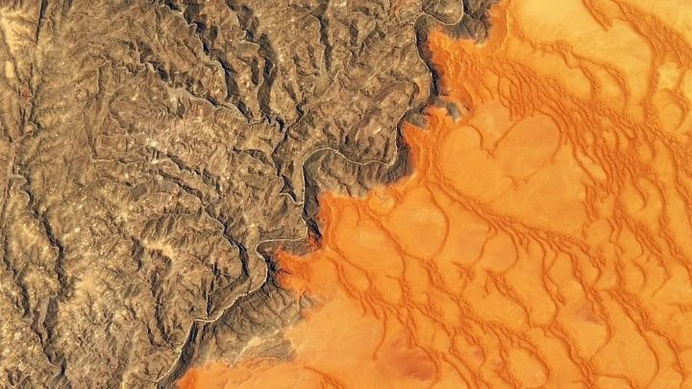
Namib-Naukluft Park. (Joshua Stevens / NASA Earth Observatory)
This image, taken by Landsat 8 on November 13, 2019, shows the striking color contrast between the Namib Sand Sea, the world's only coastal desert, spanning over 26,000 square kilometers, and the rocky mountains of the country. Namib-Naukluft Park. Both are in Namibia (country in South Africa).
The dunes appear a red-orange color due to the presence of iron oxide. According to the Earth Observatory, the Kuiseb River, which is prone to flooding, has prevented sand from entering the mountain.
3. Yukon-Kuskokwim soaked in color
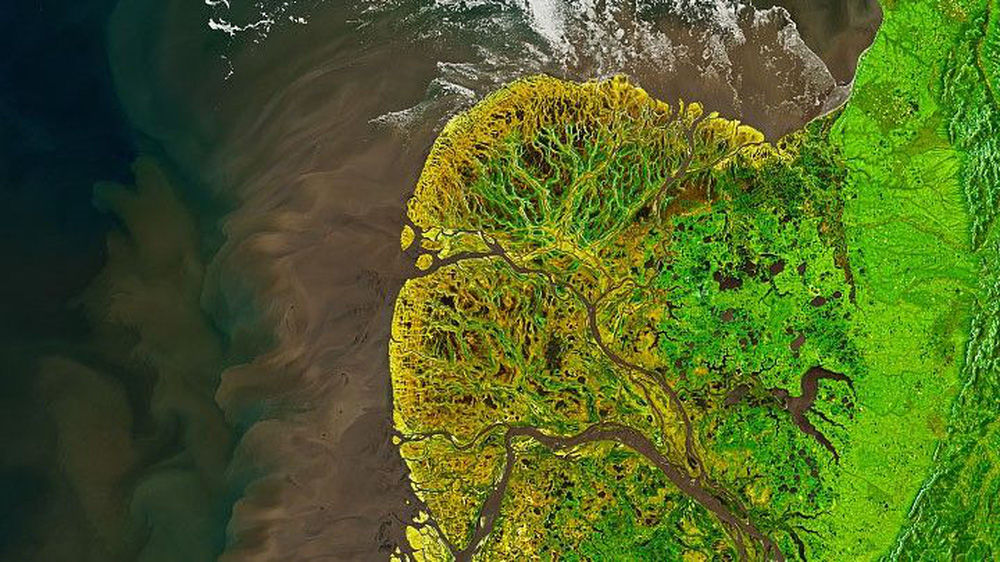
Yukon-Kuskokwim Plain. (Joshua Stevens / NASA Earth Observatory)
This image is of the Yukon-Kuskokwim Plain, where the Yukon River empties into the Bering Sea in Alaska, USA taken on May 19, 2021, by Landsat 8.
The colors on the land have been enhanced in this photo: Green highlights live vegetation; yellow is bare land; and light brown is dead vegetation.
Gerald Frost, a scientist at ABR, Inc., an Alaska-based Environmental Services and Research Company, told the Earth Observatory: "The Yukon Delta is an exceptionally vivid landscape even from the surface. earth, from the air or from low Earth orbit".
4. Unique mystery from Russia
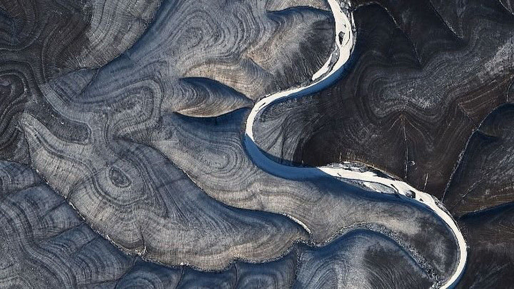
Markha River. (Joshua Stevens / NASA Earth Observatory)
Landsat 8 captured this image of eerie ripples in the hills around the Markha River in northern Russia on October 29, 2020. Alternating light and dark stripes are visible all around but clearly clearer in winter.
Scientists aren't exactly sure why this pattern exists. It can emerge from the constant freezing and melting of the permafrost; or due to some unique type of erosion because of rain or snow melt.
5. Ginseng farm in northern China
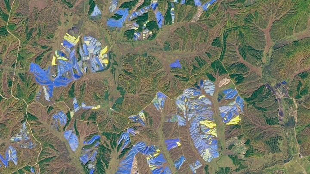
Agricultural land in Heilongjiang province. (Joshua Stevens / NASA Earth Observatory)
On September 25, 2017, Landsat 8 captured this image of blue, purple, and yellow structures covering large areas of farmland in Heilongjiang province, northeastern China.
The blue and yellow pictures are plastic shade covers used in ginseng cultivation.
In many Asian countries, ginseng is believed to have many medicinal properties, and the cultivation of the plant has become a billion-dollar business, according to the Earth Observatory.
6. Draw the hills of Pennsylvania
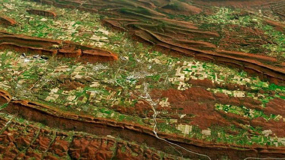
The tectonic plates in central Pennsylvania. (Joshua Stevens / NASA Earth Observatory)
This dramatic image is a combination BETWEEN satellite images of the folding mountains - warping mountains formed at the boundary between two tectonic plates - in central Pennsylvania (USA), taken by Landsat 8 on November 9, 2020, WITH a digital elevation model to highlight the topography of the area.
These mountains are part of the unique geological region of the Appalachian Mountains, known as the Valley and Ridge Belt, which stretches from New York state to Alabama.
In addition to showing off the unusual shapes of the mountains, this naturally colored photo also shows the palette of autumn colors created when leaves turn red and begin to fall from deciduous trees, according to the Earth Observatory.
7. Jason and the Bloomonauts
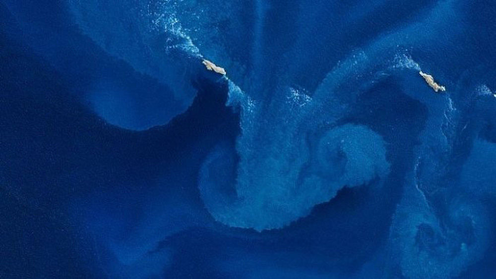
(Joshua Stevens / NASA Earth Observatory)
This beautiful natural color image of an algae bloom around the western part of the Jason Islands, an archipelago in the South Atlantic, was taken by Landsat 8 on October 18, 2020.
The milky blue swirls are caused by the rapid growth of photosynthetic algae, which thrive in nutrient-rich waters that have been enriched by the Malvinas Current - a tributary of the Circumpolar Current of the Southern Ocean, sucking nutrients from the Deep Ocean, according to the Earth Observatory.
8. Lake Natron
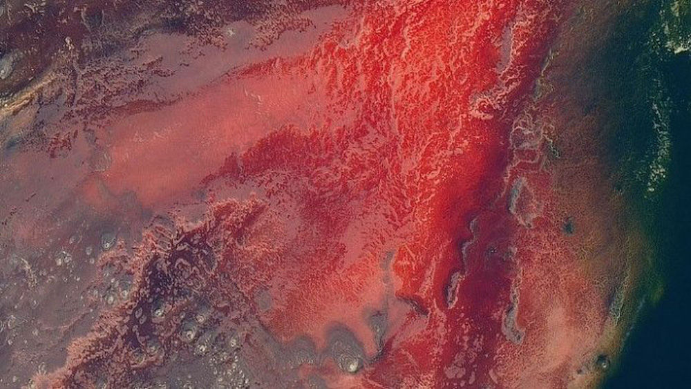
(Joshua Stevens / NASA Earth Observatory)
This striking aerial photograph of the blood-red Lake Natron in Tanzania (country in East Africa) was taken by Landsat 8 on March 6, 2017.
Lake Natron is a mineral-rich freshwater lake. This dramatic color is caused by a molten mixture of sodium carbonate and calcium carbonate salts from nearby volcanoes entering the water through hot springs.
With an average temperature of 40 degrees Celsius and less than 500 mm of rain a year, it is one of the most extreme environments on Earth, according to the Earth Observatory.
9. The Ice Art of the Strait of Sannikov
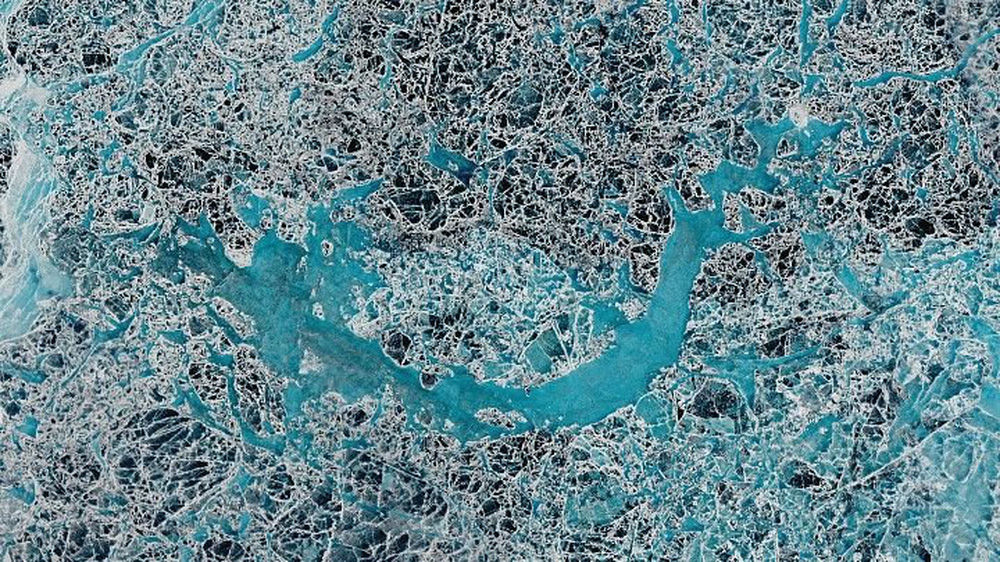
(Lauren Dauphin / NASA Earth Observatory)
This fascinating photo of the Sannikov Strait - a body of water located between the New Siberian archipelago to the north of mainland Russia - was taken by Landsat 8 on June 5, 2016.
The strait that connects the Laptev Sea to the west with the Siberian Sea to the east remains covered with ice for most of the year, Live Science reports.
This photo shows the icebergs breaking off during the summer and creating a picturesque panorama.
10. The largest lithium battery on the planet
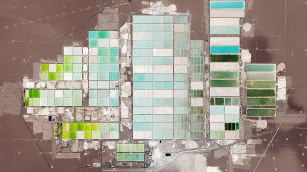
(Lauren Dauphin / NASA Earth Observatory)
This colorful array of cubes is found in the Salar de Atacama - home to the largest salt flat in Chile - and home to the world's largest lithium plant. This unique photo was taken by Landsat 8 on November 4, 2018.
Lithium is a key component of batteries needed to power our cars, mobile phones, laptops and other rechargeable devices.
Lithium is usually separated from salt and sea water. This plant pumps lithium-rich brine from below the surface and delivers it to evaporation pools, where the Sun evaporates the water, leaving pure lithium.
The different colors in the image are the result of different stages of the evaporation process, according to the Earth Observatory.
Our planet, if viewed from above, is not so magnificent and beautiful!
Thanks for watching!