Table of Contents >> Show >> Hide
- The Discovery That Started With a “What Is That Blob?” Moment
- Meet the Wreck: The Story of Frank D. Barker
- Why This Discovery Matters Beyond the Headline
- How Shipwreck Discovery Works in 2026
- The Great Lakes Are Still an Active Underwater Archive
- Weather, Risk, and Why Ships Kept Disappearing
- Legal and Ethical Reality: Look, Learn, Don’t Loot
- Shipwreck Tourism Can Be ExcellentIf It’s Done Right
- What Content Creators and Marketers Should Learn from This Story
- Conclusion
- Experience Add-On: From the Waterline
Most people use satellite maps to find coffee shops, shortcuts, or that one beach parking lot that “definitely exists.”
Matt Olson, a boat tour guide in Door County, Wisconsin, used satellite imagery and found something a lot less caffeinated and a lot more historic:
the remains of a long-lost 19th-century schooner. Better yet, this wasn’t beginner’s luck. It was his third major shipwreck discovery.
Yes, third. At this point, if shipwrecks had feelings, they’d probably start checking whether Matt is scouting nearby.
But behind the headline is a bigger storyabout maritime archaeology, community knowledge, modern detection technology, preservation law, and why the Great Lakes
still hold some of the most important underwater history in North America.
In this deep dive, we’ll unpack how a tour guide became an accidental maritime detective, what we know about the newly identified wreck,
and why this discovery matters far beyond one dramatic photo from Lake Michigan.
The Discovery That Started With a “What Is That Blob?” Moment
From Route Planning to Real Archaeology
Olson was reportedly scouting locations for his tour business near Rowley’s Bay when he noticed an unusual dark shape in satellite imagery.
Instead of shrugging and saying, “Probably just weird water,” he did what curious water people do: he investigated.
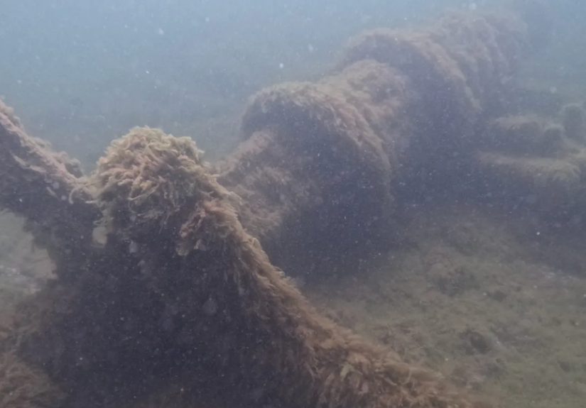
Using sonar and an underwater camera, he helped confirm a large wooden wreck in roughly 24 feet of watersurprisingly shallow for a site that remained undiscovered for generations.
Follow-up dives by maritime archaeologists identified the wreck as the Frank D. Barker, a two-masted wooden schooner tied to a documented 1887 loss near Spider Island Reef.
The vessel had been missing for about 138 years, depending on the timeline you use. In shipwreck terms, that counts as a very long “be right back.”
Why “Third Discovery” Is a Big Deal
Olson had already been linked to two other significant finds: the Grey Eagle and the Sunshine, both 19th-century schooners connected to Door County waters.
Finding one wreck can be luck plus obsession. Finding three suggests pattern recognition, local expertise, and a persistent eye for anomalies most people never notice.
Meet the Wreck: The Story of Frank D. Barker
A Schooner Built for Great Lakes Commerce
The Frank D. Barker was built in 1867 and worked the Great Lakes trade routes in the era when schooners hauled cargo that fueled industrial growth across the Midwest.
Think coal, grain, and iron orenot glamorous cargo, but exactly the stuff that built cities, railroads, and manufacturing economies.
Vessel records describe a ship around 137 feet long, wood-hulled, two-masted, and designed for the demanding logistics of trans-lake shipping.
This wasn’t a tiny local craft; it was a working machine in a large commercial network.
What Happened in 1887?
Historical records indicate the schooner stranded in thick weather while heading toward Escanaba for iron ore.
Salvage attempts followed but failed, and the vessel was eventually lost to the reef environment and lake dynamics.
Over time, memory of the precise location faded, while the wreck itself became part of the underwater landscape.
That’s one reason these discoveries are so compelling: they close loops that have been open for more than a century.
Archival notes, old newspaper references, oral history, and modern field methods suddenly alignand a “missing” chapter gets a map pin.
Why This Discovery Matters Beyond the Headline
1) It Validates Citizen Discovery as a Serious Pipeline
Maritime archaeology is increasingly collaborative. Agencies and trained archaeologists do the formal documentation, legal protection, and interpretation.
But initial leads often come from fishers, divers, captains, charter operators, and yestour guides.
Olson’s find is a textbook example of that model: local observation, targeted follow-up, then professional verification.
This is exactly how modern heritage science can scale in a region with thousands of potential sites.
2) It Strengthens Regional Maritime Identity
Door County is not just “pretty coastline + good fish fry.” It’s a layered maritime corridor with dense ship traffic history and known hazards.
A newly identified wreck becomes more than an artifact scatter; it becomes a narrative anchor for local education, museum interpretation, and responsible heritage tourism.
In plain English: when communities can point to real, documented sites, history stops feeling abstract and starts feeling local.
3) It Adds Urgency to Documentation Efforts
Archaeologists and conservation teams have warned that invasive quagga mussels are rapidly changing Great Lakes wreck environments.
Mussel encrustation can stress wooden structure, alter site conditions, and complicate interpretation.
So every newly located wreck is not just excitingit is time-sensitive.
How Shipwreck Discovery Works in 2026
Step 1: Locate Promising Anomalies
Satellite imagery, historical charts, hydrographic clues, old incident reports, and local boating knowledge can all point to potential targets.
Most leads are nothing. Some leads are history.
Step 2: Scan with Sonar
Side-scan sonar remains one of the most effective first-pass tools for underwater target detection.
It sends acoustic pulses that generate dark/light contrast images of the seafloor, helping teams identify hard objects, shapes, and shadows consistent with wreck structure.
Step 3: Confirm with Visual Survey
Divers, drop cameras, ROVs, and high-resolution imaging are used to verify whether the target is actually cultural material.
In recent NOAA-led operations, advanced systemssometimes including AUV/ROV platforms and laser-assisted imaginghave dramatically improved site documentation quality.
Step 4: Match to Records
Archaeological identification is basically forensic storytelling: dimensions, timber details, location context, cargo history, and loss records are compared until one vessel identity fits best.
It is meticulous work, not guesswork.
Step 5: Protect and Interpret
Once identified, sites may be evaluated for state and federal registries, integrated into maritime heritage databases, and managed for public education and controlled recreation.
Good discovery ends with stewardship, not souvenir hunting.
The Great Lakes Are Still an Active Underwater Archive
Estimates vary, but thousands of shipwrecks are believed to lie across the five Great Lakes, with many still undiscovered.
NOAA and partner organizations have repeatedly framed the region as one of North America’s most important underwater cultural landscapes.
Great Lakes waters can preserve wrecks remarkably well compared with saltwater environments, especially at depth and in colder conditions.
That makes these sites invaluable for studying vessel construction, trade patterns, maritime labor, and even climate-era risk through long historical timelines.
Put simply: each wreck is a time capsule. Together, they form a floating (well, sunken) archive of American commerce and migration.
Weather, Risk, and Why Ships Kept Disappearing
If you think of the Great Lakes as “inland seas,” shipwreck history makes immediate sense.
Sudden fog, reef zones, high-energy shorelines, rapid wind shifts, and violent fall storms have challenged mariners for centuries.
Historic events like the 1913 “White Hurricane” remain benchmark reminders of just how fast conditions can turn catastrophic.
This context matters for interpreting 19th-century losses: many disasters involved navigation under limited visibility, constrained forecasting tools, and vessels loaded for demanding routes.
The past wasn’t less complicated. It was less forgiving.
Legal and Ethical Reality: Look, Learn, Don’t Loot
U.S. and state frameworksincluding the Abandoned Shipwreck Act and Wisconsin protectionstreat historic wreck sites as public heritage resources, not private treasure chests.
That means removing or damaging artifacts can trigger serious legal consequences.
Responsible divers and tour operators understand this clearly: visiting a wreck is a privilege tied to preservation ethics.
The goal is to pass the site forward intact, not bring a “cool old thing” home in a backpack.
Shipwreck Tourism Can Be ExcellentIf It’s Done Right
Education Beats Exploitation
Tourism around shipwreck coasts can support local economies while strengthening historical literacy.
Guided tours, museum exhibits, dive briefings, and citizen science participation can turn curiosity into stewardship.
The key is framing. “Come see a spooky old wreck” gets clicks.
“Come learn how this wreck connects to labor, technology, weather, immigration, and law” builds durable public value.
The best operators do bothand maybe throw in a lighthouse and a few dad jokes along the way.
Why Guides Are Quiet Superheroes of Public History
Tour guides stand at the intersection of storytelling and place-based evidence.
They are often the first to notice ecological changes, unusual visibility, emerging hazards, and odd seafloor features.
In other words, they’re informal sensors in a giant living archive.
Olson’s third find is a reminder that expertise doesn’t always wear a lab coat.
Sometimes it wears a life jacket and checks satellite tiles at midnight.
What Content Creators and Marketers Should Learn from This Story
If you publish in travel, history, education, or outdoor niches, this story is a masterclass in high-engagement, high-integrity content:
- Human hook: one person, one unexpected discovery, high curiosity.
- Evidence spine: archival records + scientific tools + agency verification.
- Broader stakes: preservation law, invasive species, cultural memory.
- Evergreen angle: “How discoveries happen” stays relevant beyond the news cycle.
- Local-to-national lift: a regional event that speaks to U.S. heritage at scale.
In SEO terms, this topic naturally supports clusters around Great Lakes shipwrecks, maritime archaeology,
Lake Michigan history, shipwreck preservation, underwater heritage tourism, and sonar mapping.
No keyword stuffing requiredjust solid structure, useful detail, and credible context.
Conclusion
“A tour guide found his third lost shipwreck” sounds like a perfect headline because it is.
But the real story is richer: careful observation met modern technology, then moved through professional archaeology into public heritage.
That processcuriosity, verification, preservationis the model.
The Frank D. Barker discovery is not merely a cool local anecdote.
It is proof that the Great Lakes still hold major historical resources in plain sight, waiting for the right combination of persistence and method.
In an age of fast content and short attention spans, this is a rare narrative that rewards looking deeperliterally and culturally.
And if a satellite “blob” can reconnect a modern community with a 19th-century maritime chapter, maybe history isn’t lost as often as we think.
Sometimes it’s just wet, patient, and waiting for someone curious enough to stop the boat.
Experience Add-On: From the Waterline
If you’ve never stood on a small boat over a wreck site in Lake Michigan, let me paint the scene.
The water can look deceptively calmlike a giant blue sheet pretending it has never caused trouble in its life.
Then the wind shifts, the chop starts tapping the hull, and everyone suddenly understands why mariners respected this lake like a moody giant.
The first thing that surprises people is how emotional shipwreck stories become once you’re physically there.
On a map, a wreck is a point. On the water, it feels like a memory with coordinates.
You look down and realize that beneath your feet is not just timber and iron; it’s a workplace, a route, a risk, a bad weather decision, and a hundred unfinished conversations from another century.
I’ve watched guests go from “This is cool!” to silently staring over the side with a completely different expression.
They start asking better questions.
Not “How much is treasure worth?” but “Who built this?” “What were they carrying?” “Did everyone survive?” “How did they navigate in fog back then?”
That is the exact moment a boat ride turns into history education.
There’s also a practical side that people don’t see in the headlines.
Conditions change constantly. Visibility can swing. Wind can force route adjustments.
Equipment needs backup plans. And every responsible operator knows that excitement has to be balanced by safety and respect for protected sites.
The lake does not care if your social media post is behind schedule.
One of my favorite patterns is watching kids onboard. They are usually the fastest to grasp the big idea:
“Wait, this stuff is real? It’s still down there?”
Yes. And that simple realization can spark a lifelong interest in science, diving, local history, or conservation.
A lot of adults rediscover that same wonder, just with more expensive sunglasses.
When people hear that a guide found a third wreck, it can sound like an unbelievable lucky streak.
But what it really reflects is long-term attention.
People who spend years on one shoreline notice tiny anomalies. They remember old stories. They track currents, storms, and shoals.
Eventually, pattern meets opportunity.
The deeper lesson is about stewardship.
A shipwreck is easy to sensationalize, but hard to preserve.
Preservation means documenting details before they degrade, discouraging artifact removal, supporting archaeological surveys, and teaching visitors how to engage without harming the site.
It is slower than treasure-hunt fantasyand far more valuable.
So if you ever join a shipwreck tour, treat it like entering a museum with no roof.
Ask questions. Listen hard. Keep your hands off protected artifacts.
Let the guide do what great guides do: translate water into story.
And if someone onboard says, “I think I see something strange on the satellite image,” maybe don’t laugh.
In Door County, that’s apparently how chapter three begins.
Research Basis Used for Synthesis
This article synthesizes reporting and documentation from U.S.-based sources across journalism, public agencies, and heritage records, including AP, NOAA programs, NPS, USGS, NWS, Wisconsin maritime archives, and major science/history publications.